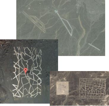
What is the strange thing found on Google Maps out in the Gobi Desert? The stripes are exactly 20m across and seem to have been painted. Zoom out and go eight miles west of the grid and you’ll find another. Between them, about six miles west, are three striped arrangements – apparently runways – at similar angles. Look closely near the middle one, and you’ll see what looks like abandoned buildings laid out as a factory, prison or military facility might be.
The stripes seem to be painted or otherwise applied straight onto rock. They also seem quite old and worn away.
My hunch: Cold War-era ‘fake’ runways and settlements, designed to trick the US U-2 flights – or perhaps the Soviets – into thinking that this remote region of China was better defended and more populous than it really was.
More here.


Nah, La Parisian Billionaire Residence Golden Eagle condominiums mate.
Can’t you just streetview it?
But seriously, old news:
http://bbs.keyhole.com/ubb/ubbthreads.php?ubb=showflat&Number=504658&page=1
It’s Hong Kong’s roadmap for democracy.
Or a map of John Tsang’s brain : hardly any neurons and a real mess inside
3000 meters long, 60 meters wide.
The first two might just be what they look like ; runways.
Yep – very high res on Google Earth now … the one in the center looks like it is a runway and parallell taxiway/runway – paved level, with peripheral drainage and roads. 40°28’4.47″N 93°31’8.92″E
The straight one further east appears to be a single runway, level paved, perhaps disused as is partially eroded to one end.
The one on the left (further west) appears to be a fake runway, painted over eroded ground. 40°27’4.49″N 93°23’56.72″E
Got no idea of the zig zag grid… but given the hundreds of wheel/track marks in the desert, that the whole shebang is a miltary training area seems a good guess.
These have been explained – they are ‘test patterns’ to calibrate spy satellites.
http://www.livescience.com/17052-mysterious-symbols-china-desert-spy-satellite-targets-expert.html